|
Home
Participation rules
Race Info
Friday
Sat / Sun
SE Interscholastic Championships
Schedule
Registration/Fees
T-shirt
Lodging/Travel
Accommodations
Tourism
Volunteers
Contacts
Meet Guide
Mixed Punching
 Georgia Orienteering Club
 NATIONAL RANKING EVENT
|
Sat, Jan 13 & Sun, Jan 14 -- Red Top Mountain State Park
Support the Jr Team
OUSA's Jr Squad is providing a bake sale to support summer traveling expenses in 2024. A table will be set up at the meet HQ Saturday selling drinks and baked goods. All allergens will be listed on the item for sale. Venmo and cash will be accepted and cash donations to the team are welcome! If you would like to donate a food item, there is a sign-up sheet here.Location
Red Top Mountain State ParkAddress: 50 Lodge Road SE, Acworth, GA 30102
Typically less than 1 hr 30 mins drive from Atlanta International Airport Rental Car Center on Friday mornings.
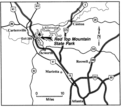
Click map to open in a new window.
Red Top Mountain State Park website (includes Maps and Directions)
*** Please obey the park speed limits at all times ***
Site Map - Park Overview
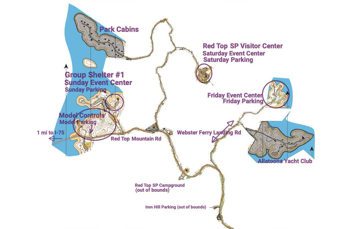
Click map to open in a new window.
Saturday Meet HQ
Red Top Mountain State Park -- Visitor CenterAccess via Park Marina Rd (inside the park), turn right onto Lodge Rd.
Sunday Meet HQ
Red Top Mountain State Park -- Group Shelter #1Access via Red Top Beach Rd (inside the park).
Registration & Check in
Saturday -- Packet pick up will be available from 8:30 am - 12:00 pm at Meet HQ, Red Top Mountain State Park Visitor Center.
Sunday -- Packet pick up will be available from 8:30 am - 12:00 pm at Meet HQ, Red Top Mountain State Park, Group Shelter #1.
Site Map
Saturday Site Map
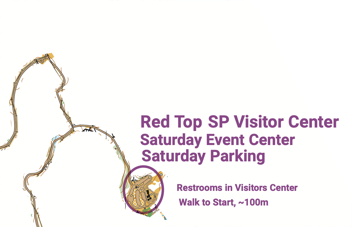
Click map to open in a new window.
Sunday Site Map
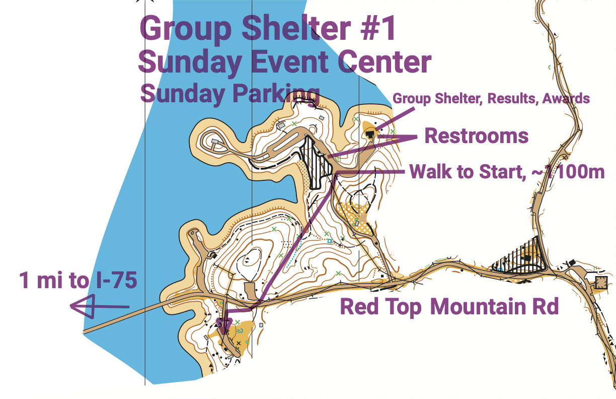
Click map to open in a new window.
Starts
Saturday Starts will be from 10:00 am - 1:00 pm. Maximum Time is 3 hours. Courses close at 4:00 pm.Sunday Starts will be from 9:30 am - 12:30 pm. Maximum Time is 3 hours. Courses close at 3:30 pm.
Map
- White, Yellow, Orange, Green, F-18 (on Brown) and Red (except F-21+) : Map scale is 1:10,000 with 5 meter contours.
- M/F-21+ : Map scale is 1:15,000 with 5 meter contours.
- All Brown courses except F-18 : Map scale is 1:7,500 with 5 meter contours. F-18 will be 1:10,000.
Embargo
Entire Red Top Mountain State Park is embargoed from June 1, 2023.The old Red Top Mountain State Park map is available to download here.
Course maps from various GAOC local events are on GAOC's RouteGadget here.
Courses
| Course | SE Interscholastic Classes | OUSA Classes | Sat Dist / Climb / Cntrls | Sun Dist / Climb / Cntrls | Map Scale |
|---|---|---|---|---|---|
| White | F-10, F-12 M-10, M-12 M/F White, Grp White | 2.2km / 65 / 13 | 2.1km / 70 / 12 | 1:10,000 | |
| Yellow | ISIF, ISIM | F-14, M-14 F Yellow, M Yellow, Grp Yellow | 2.7km / 80 / 13 | 2.4km / 90 / 12 | 1:10,000 |
| Orange X | ISJVM | M-16, M Orange | 4.0km / 200 / 11 | 4.0km / 170 / 14 | 1:10,000 |
| Orange Y | ISJVF | F-16, F Orange | 4.0km / 210 / 10 | 3.7km / 175 / 13 | 1:10,000 |
| Brown X | F55+, F60+, F65+, F Brown M65+, M70+, M75+, M Brown | 4.0km / 210 / 11 | 4.4km / 180 / 13 | 1:7,500 | |
| Brown Y | F70+, F75+, F80+ F85+, F90+ M80+, M85+, M90+ | 3.7km / 160 / 9 | 4.2km / 200 / 13 | 1:7,500 | |
| Brown Z | ISVF | F-18 | 4.5km / 245 / 13 | 4.4km / 180 / 13 | 1:10,000 |
| Green X | ISVM | M-18 M50+, M55+, M60+ M Green | 5.1km / 240 / 14 | 5.5km / 260 / 14 | 1:10,000 |
| Green Y | F-20 F35+, F40+, F45+, F50+ F Green | 4.7km / 250 / 13 | 5.0km / 225 / 15 | 1:10,000 | |
| Red X | M-20, M35+, M40+, M45+ M Red | 6.5km / 355 / 17 | 7.2km / 290 / 17 | 1:10,000 | |
| Red F21 | F-21+ | 6.5km / 355 / 17 | 7.2km / 290 / 17 | 1:15,000 | |
| Blue | M-21+ | 9.1km / 385 / 24 | 9.4km / 315 / 22 | 1:15,000 |
Restrooms
Saturday: Restrooms are available in the park Visitors' Center. No studs or cleats of any kind are allowed in any buildings! Also there will be porta-potties near the Start.Sunday: Toilets are available in the Group Shelter, in the parking lot and in the parking lot near the Start.
Cell Phone Service
Cell phone coverage is generally good for all carriers.Parking
Saturday: Please car pool! Parking is available in the Visitor Center area. Please cooperate with the parking volunteers' instructions.
Sunday: Parking is available in the Group Shelter #1 area.
All passenger vehicles must have a state park parking pass. Rates are charged based on vehicle capacity, not the number of actual passengers.
Cars and vans with 1-12 passenger capacity are $5/day. You will need a pass for each day you are in the park. Georgia Yellow School buses
are state vehicles and are exempt from parking charges and do not require a parking pass. Buses, other school buses and 13+ passenger vehicles MUST
display a Park Pass each day.
If you are bringing a bus, please contact the Meet Director in advance
You risk a ticket without a parking pass!
You can pull an envelope from the green boxes in the parking areas and follow the instructions if you use cash.
You can buy your Daily Park Pass online.
You can print your pass and place it on your dashboard or simply pull an envelope and write your pass number on it before placing it on your dashboard
Practice Map
A model map is available at the west end of the park. See the Site Map - Park OverviewBabysitting
Babysitting will not be provided. Please do not plan on just leaving your young child at the Meet HQ. Please let the Registrar know if you have special start time requests that would help your own child care arrangements.
Emergency Information
In the case of a life-threatening emergency, call 911.
First aid kits and an AED will be located at Meet HQ.
Should you require additional medical aid, the nearest hospital emergency room is:
Piedmont Cartersville Medical Center, approximately 11 miles (20 minutes) northwest of Red Top Mountain State Park
The contact information is 960 Joe Frank Harris Pkwy SE, Cartersville, GA 30120 (470) 490-1000
Search and Rescue (SAR)
The SAR coordinator is Fred Zendt. His cell phone number is 678-640-5828. Put this number in your cell phone now.
He can be found through Meet HQ.
Please coordinate the search and rescue of all missing or injured persons through Meet HQ.
Do not attempt search and rescue operations of your own.
Time Limits
Time limit is 3 hours on all courses. You must return to the Finish, punch the Finish control and Download your e-stick within 3 hours after you start, whether you complete your course or not. Do not go out on a course if you do not have the means to tell the time and how long you have been out. This generally means a watch or a cellphone.
Safety
If you have been out for 3 hours or it is clear that you cannot finish in 3 hours, you must stop immediately and report to the Finish.
Saturday Safety Bearing: Go west to the paved road on the N-S ridge in the middle of the map or south to Red Top Mountain Rd. Then stay on the road.
Meet personnel will patrol the roads for competitors in need.
If unsure, STAY on any road you come across.
Meet personnel will patrol the roads for competitors in need.
If unsure, STAY on any road you come across.
Carry a whistle. One will be provided upon request. Three (3) short blasts from a whistle indicate an emergency. Blowing the whistle otherwise will result in Disqualification. If you are lost after the courses close, you are already disqualified, and it is an emergency. Please blow your whistle so that we can locate you before it gets dark. You are encouraged to carry a cell phone to be able to call in an emergency. If your calls do not go through, try text messages. Before starting your course, make a contingency plan. Share your start time, expected finish time and contact details with someone who can raise the alarm. The courses close at 4:00 pm. Sunset is at 5:54 pm and last light is at 6:21 pm.
Dress appropriately for the weather conditions. Weather conditions in Georgia in January vary from freezing and/or cold rain to very pleasant. If the ground is wet, exposed red clay will be extremely slippery. Please be careful not to slip on it.
Assist an injured competitor. If another competitor is hurt and in need of assistance, help to the best of your ability or go to summon help. Report the injured competitor’s bib number and exact location to officials at the Finish or Start line.
Warm Up Area
You may warm up along the roads around Meet HQ or towards the Start. Please watch out for vehiclesClothing Return
Sunday - No clothing return is provided. Start area is only 100m from the parking lot.Saturday - No clothing return is provided. Clothing drop off is next to the Finish area, approximately 200m from the Start Area.
Walk to Start
Routes will be clearly marked with signs.Saturday walk is 100m from Meet HQ.
Sunday walk is 1100m from Meet HQ. Follows signs and streamers. Please be extremely careful when crossing Red Top Mountain Rd.
Rest rooms both days are at the Meet HQ and near the Start area.
Control Descriptions
Will be available at the Start mid-line (1-min to go). Also printed on the map.Call Up
Be at the Call-up area approximately 5-10 minutes before your Start time.
Call up is 3 minutes before your start time.
Start procedure will consist of three one-minute stages: Call-up, Mid line and Map lines.
Control descriptions will be available and will also be printed on your map.
At the Map line you will receive your map. Markers will be available to write your bib number on the back of the map.
If you finish before the last start, we will collect your map at the finish. You may retrieve your map once all competitors have started.
There are only sufficient maps for each person to have one each day, so please do not take anyone else’s.
Finish Line
When arriving at the finish line, be sure you punch the “Finish” control at the Finish banner.
Proceed immediately to the Download Station to have your e-stick read. Take the printout of your results and split times.
If not all competitors have started, you will be asked to turn in your map and pick it up later. Once you have finished, you may not re-enter the competition area without permission of the Meet Director.
Rental e-sticks must be turned in on the last day of your competition at the Download Station.
Map and Course Setter Notes
Red Top Mountain State Park is mostly ridge and reentrant terrain. The map uses symbols set forth in ISOM 2017. North lines are spaced at 300m. Map scale is 1:10,000 with 5m contours with the exception of Brown-X and Brown-Y courses which are printed at 1:7,500 and F/M-21+ which are printed at 1:15,000.The Park is surrounded on three sides by Lake Allatoona, a U.S. Army Corps of Engineers reservoir on the Etowah River. As a reservoir, the lake level fluctuates throughout the year. Currently, the lake level is 12-13 feet below full pool, exposing boulders, tree stumps, and hills that are normally submerged. Features that would be submerged if the lake were full are not mapped. The full pool level is represented on the map with the earth bank symbol (without tags), and the estimated lake level is represented with the uncrossable body of water symbol. The area between the full pool level and the estimated lake level is represented with the rough open land symbol. Generally, the exposed area between the actual shoreline and full pool is runnable (although muddy close to the water). A few locations are very rocky and hardly passable. These rocky areas are not mapped. Keep this in mind when choosing your routes.
Individual boulders that are 1 to 1.5 meters high are represented on the map with the regular boulder symbol. The medium boulder symbol is used for boulders 1.5 -2 meters high. The large boulder symbol is used for boulders higher than 2 meters. Individual boulders less than 1 meter high are not mapped. The boulder cluster symbol (equilateral triangle) is used for a group of boulders (each at least 1 meter high) that are too close to map individually. The boulder field symbol (scalene triangle) is used for a group of scattered boulders that are typically 0.5 to 1 meter high or at least 1 meter wide.
Deadfall that impedes running but does not impede visibility is mapped with vertical green lines (vegetation, slow running, good visibility).
Features mapped as rides are old road beds, often so old that they are barely discernable when running across, but are usually easy to follow when running along.
Non-standard symbols used are:
- Rootstocks are mapped with the green “X” symbol (prominent vegetation feature). Rootstocks less than 1 meter high are not mapped.
- Black ‘O’ used for "junk pile". Must be ~1m high or otherwise very visible.
- Black ‘X’ used for man-made object that is not trash/junk. Must be ~1m high or otherwise very visible.
- Yerts in the campground are mapped with a round canopy symbol.
The competition maps have an abbreviated legend with just the most commonly used and relevant map symbols.
A more extensive, complete map legend (as shown in the Mapper's Notes) is available to
download here.
Saturday
Saturday courses are in the steepest area of the park, with very little green on the map. The woods are open and beautiful, runnability is excellent, but the hills are steep!All Saturday courses cross the roads you drove in on. Please exercise caution when crossing the road and while driving.
Water for orienteering participants is placed at several locations along the park roads, as indicated with the water cup symbol on your maps.
Sunday
Compared to Saturday, the Sunday courses have less climb, a little light green in one section of the map, and a lot more boulders. All the Sunday advanced courses cross through the state park campground. Please be respectful of the other park users. Do not run directly through their campsites.The walk-to-start on Sunday crosses Red Top Mountain Rd which is the main road passing through the park. Please be extremely careful when crossing the road as traffic on it generally moves much faster than it should.