|
Home
COVID rules
Race Info
Friday
Sat / Sun
OUSA Junior Championships
Schedule
Registration/Fees
T-shirt
Lodging/Travel
Accommodations
Tourism
Volunteers
Contacts
Meet Guide
Mixed Punching
  Georgia Orienteering Club
 NATIONAL RANKING EVENT
|
Sat Jan 14 & Sun Jan 15 -- F.D. Roosevelt State Park
GAOC is implementing special COVID rules for event participants to maintain the health and safety of all participants and volunteers and to comply with state and local laws and park regulations. By entering in and attending the event you are agreeing to abide by these rules. Please make sure you read and understand them
In particular, please read, understand and comply with the rules on Masks, Social Distancing, Start, Finish and Results. There will be NO water on the course. Participants are strongly encouraged to carry water according to their needs
Participants should NOT attend if they feel unwell, have a fever, have recently been exposed to COVID-19 or should be in quarantine for any reason
Location
F. D. Roosevelt State ParkPark office address and phone: 2970 Georgia Highway 190, Pine Mountain, GA 31822, (706) 663-7463
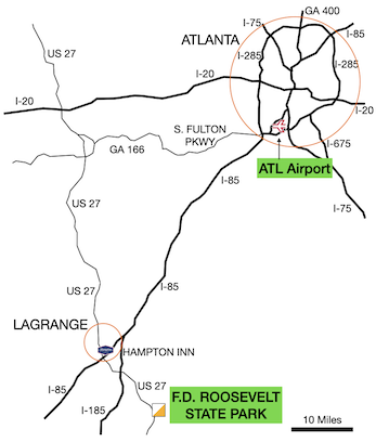
Click map to open in a new window.
Meet HQ
Meet HQ is at the F.D. Roosevelt State Park Event Center - located in the SE corner of the park, on the west side of Lake Franklin.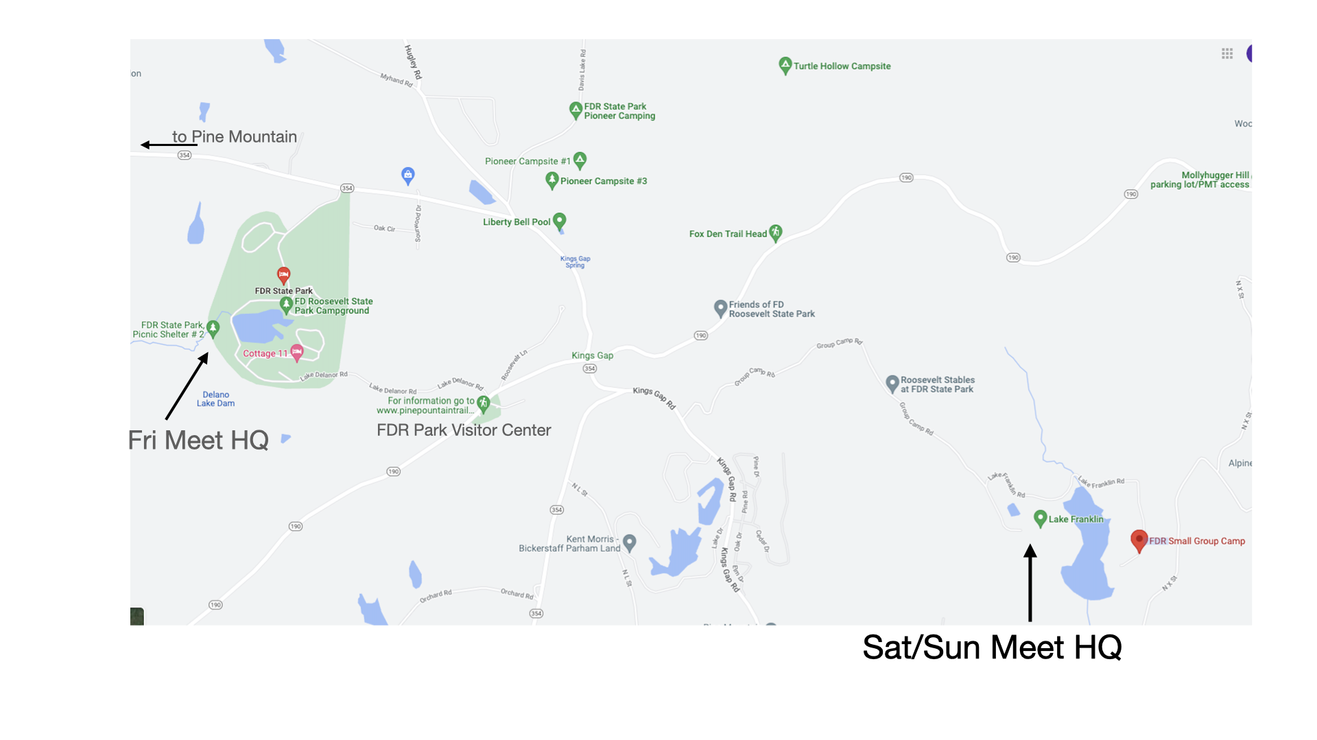
Click map to open in a new window.
Site Map
TBDRegistration & Check in
Friday -- Packet pick up will be available from 11:00 am - 4:30 pm at Friday Meet HQ, FDR State Park, Lake Deleanor Group Shelter.
Saturday -- Packet pick up will be available from 8:00 am - 12:45 pm at Meet HQ, FDR State Park, Event Center.
Sunday -- Packet pick up will be available from 8:00 am - 12:45 pm at Meet HQ, FDR State Park, Event Center.
Starts
Saturday Starts will be from 10:00 am - 1:00 pm. Maximum Time is 3 hours. Courses close at 4:00 pm.Sunday Starts will be from 9:30 am - 12:30 pm. Maximum Time is 3 hours. Courses close at 3:30 pm.
Map
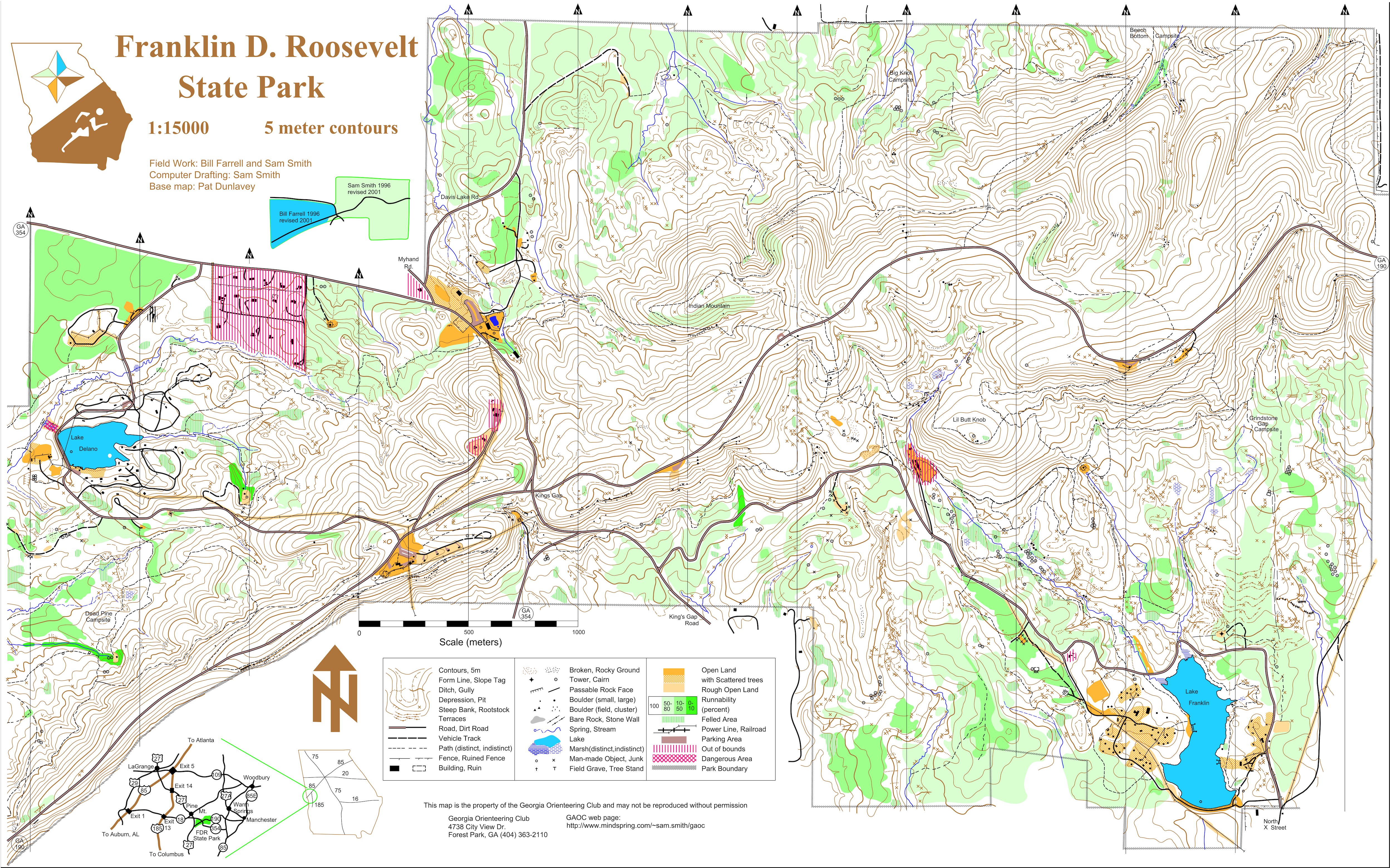
- White, Yellow, Orange, Green, F-18 (on Brown) and Red (except F-21+) : Map scale is 1:10,000 with 5 meter contours.
- M/F-21+ : Map scale is 1:15,000 with 5 meter contours.
- All Brown courses except F-18 : Map scale is 1:7,500 with 5 meter contours. F-18 will be 1:10,000.
Embargo
Entire FDR State Park is embargoed from June 1, 2022.The FDR State Park - Liberty Bell Pool map from the January 2022 Georgia Navigator Cup NRE event is available to download here.
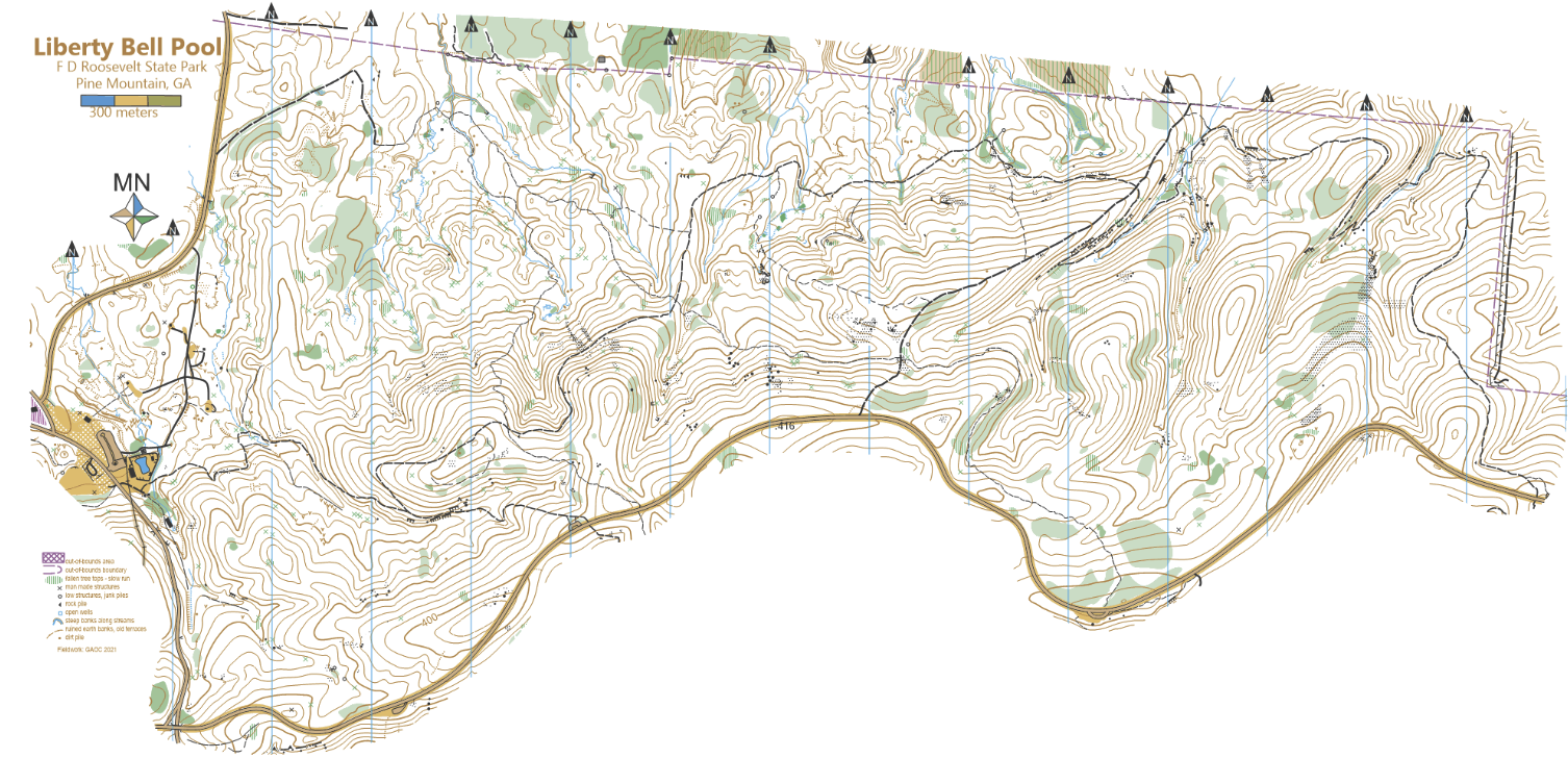
Click map to open PNG in a new window.
All course maps from the January 2022 Georgia O-Fest (GAOC Navigator Cup) NRE event are on GAOC's RouteGadget here.
The FDR State Park - Lake Franklin map from the January 2001 Georgia Navigator Cup NRE event is available to download here.
Click map to open PNG in a new window.
Courses
| Course | Jr Nat'l Classes | OUSA Classes | Sat Dist / Climb / Cntrls | Sun Dist / Climb / Cntrls | Map Scale |
|---|---|---|---|---|---|
| White | ISPF, ISPM | F-10, F-12 M-10, M-12 M/F White, Grp White | 1.7 km / 30 m / 9 | 2.2 km / 40 m / 11 | 1:10,000 |
| Yellow | ISIF, ISIM | F-14, M-14 F Yellow, M Yellow, Grp Yellow | 2.5 km / 55 m / 10 | 2.8 km / 85 m / 11 | 1:10,000 |
| Orange X | ICJVM, ISJVM | M-16, M Orange | 4.8 km / 135 m / 15 | 4.2 km / 170 m / 13 | 1:10,000 |
| Orange Y | ICJVF, ISJVF | F-16, F Orange | 4.6 km / 125 m / 14 | 4.1 km / 155 m / 13 | 1:10,000 |
| Brown X | F55+, F60+, F65+, F Brown M65+, M70+, M75+, M Brown | 4.3 km / 105 m / 11 | 4.1 km / 120 m / 10 | 1:7,500 | |
| Brown Y | F70+, F75+, F80+ F85+, F90+ M80+, M85+, M90+ | 4.0 km / 90 m / 12 | 3.6 km / 120 m / 9 | 1:7,500 | |
| Brown Z | ISVF | F-18 | 4.8 km / 110m / 13 | 4.3 km / 135 m / 10 | 1:10,000 |
| Green X | ISVM | M-18 M50+, M55+, M60+ M Green | 5.6 km / 160 m / 12 | 5.8 km / 205 m / 11 | 1:10,000 |
| Green Y | ICVF | F-20 F35+, F40+, F45+, F50+ F Green | 5.4 km / 150 m / 12 | 5.4 km / 185 m / 12 | 1:10,000 |
| Red X | ICVM | M-20, M35+, M40+, M45+ M Red | 6.8 km / 255 m / 13 | 7.4 km / 280 m / 14 | 1:10,000 |
| Red F21 | F-21+ | 6.8 km / 255 m / 13 | 7.4 km / 280 m / 14 | 1:15,000 | |
| Blue | M-21+ | 9.3 km / 360 m / 20 | 9.6 km / 335 m / 15 | 1:15,000 |
Restrooms
Restrooms are available at the Meet HQ.No studs or cleats of any kind are allowed in any buildings!
Cell Phone Service
Cell phone coverage is generally good for all carriers.Parking
Please car pool! Parking is available in the Meet HQ area. Please cooperate with the parking volunteers' instructions.
All passenger vehicles must have a state park parking pass. Rates are charged based on vehicle capacity, not the number of actual passengers.
Cars and vans with 1-12 passenger capacity are $5/day. You will need a pass for each day you are in the park. Georgia Yellow School buses
are state vehicles and are exempt from parking charges and do not require a parking pass. Buses, other school buses and 13+ passenger vehicles MUST
display a Park Pass each day.
If you are bringing a bus, please contact the Meet Director in advance
You risk a ticket without a parking pass!
You can pull an envelope from the green boxes in the parking areas and follow the instructions if you use cash.
You can buy your Daily Park Pass online.
You can print your pass and place it on your dashboard or simply pull an envelope and write your pass number on it before placing it on your dashboard
Practice Map
A model area will be available starting Friday morning, Jan 13 through Sunday. The area is on the eastern end of the Lake Delano map and was used for the Start and Finish of last year's event. Parking lot is off of GA-354, across from the Liberty Bell Pool parking area. There will be a bag will course maps on the fence next to the parking area. Please return the map for others to use after you are done. Map and course is available to download hereBabysitting
Babysitting will not be provided. Please do not plan on just leaving your young child at the Meet HQ. Please let the Registrar know if you have special start time requests that would help your own child care arrangements.
Emergency Information
In the case of a life-threatening emergency, call 911.
First aid kits and an AED will be located at Meet HQ.
Should you require additional medical aid, the nearest hospital emergency room is:
Wellstar West Georgia Emergency Department in LaGrange, GA, approximately 22 miles (30 minutes) northwest of F.D. Roosevelt State Park.
The contact information is 1514 Vernon Rd, LaGrange, GA 30240 (706) 882-1411
Search and Rescue (SAR)
The SAR coordinator is Charlie Bleau. His cell phone number is (404) 276-6558. Put this number in your cell phone now.
He can be found through Meet HQ.
Please coordinate the search and rescue of all missing or injured persons through Meet HQ.
Do not attempt search and rescue operations of your own.
Time Limits
Time limit is 3 hours on all courses. You must return to the Finish, punch the Finish control and Download your e-stick within 3 hours after you start, whether you complete your course or not. Do not go out on a course if you do not have the means to tell the time and how long you have been out. This generally means a watch or a cellphone.
Safety
If you have been out for 3 hours or it is clear that you cannot finish in 3 hours, you must stop immediately and report to the Finish.
Saturday and Sunday Safety Bearing: Go north to find a paved road. Either Group Camp Rd that you came in on or GA-190 on the top of the ridge. Then stay on the road.
Meet personnel will patrol the roads for competitors in need.
If unsure, STAY on any road you come across.
These words are also printed on the map. If you feel you are lost or need directions back to the Meet HQ, enter these three words into the what3words app. The app will then provide directions back to the finish control. Be aware that using this app, or any use of your cell phone while on the course, will result in disqualification. This app is only for emergency use when you are ready to retire from the course and competition.
Carry a whistle. One will be provided upon request. Three (3) short blasts from a whistle indicate an emergency. Blowing the whistle otherwise will result in Disqualification. If you are lost after the courses close, you are already disqualified, and it is an emergency. Please blow your whistle so that we can locate you before it gets dark. You are encouraged to carry a cell phone to be able to call in an emergency. If your calls do not go through, try text messages. Before starting your course, make a contingency plan. Share your start time, expected finish time and contact details with someone who can raise the alarm. The courses close at 4:00 pm. Sunset is at 5:54 pm and last light is at 6:21 pm.
Dress appropriately for the weather conditions. Weather conditions in Georgia in January vary from freezing and/or cold rain to very pleasant. If the ground is wet, exposed red clay will be extremely slippery. Please be careful not to slip on it.
Assist an injured competitor. If another competitor is hurt and in need of assistance, help to the best of your ability or go to summon help. Report the injured competitor’s bib number and exact location to officials at the Finish or Start line.
Some of the trails at F.D. Roosevelt State Park are for equestrian use. If you’re on a trail and meet or need to pass a horse and rider, slow down and get off the trail. Make sure not to make abrupt movements and talk calmly when approaching to avoid startling the animal. Give the horse and rider as wide a berth as possible, on the downhill side. Horses are more likely to run uphill than downhill when spooked, and you definitely don’t want to be in the path of a spooked horse.
Warm Up Area
TBD You may warm up along the roads around Meet HQ or towards the Start. Please watch out for vehiclesClothing Return
TBDWalk to Start
Routes will be clearly marked with signs. Both days the walk to Start will be back out along the road you drove in on.Saturday walk is ~700m from Meet HQ.
Sunday walk is ~700m from Meet HQ. Porta-potties both days are at the Meet HQ (Event Center) and ~200m before the Start area.
Control Descriptions
Will be available at the Start mid-line (2-min to go). Also available at packet pickup and also printed on the map.Call Up
Be at the Call-up area approximately 5-10 minutes before your Start time.
Call up is 3 minutes before your start time.
Start procedure will consist of three one-minute stages: Call-up, Mid line and Map lines.
Control descriptions will NOT be available, but will be printed on your map.
At the Map line you will receive your map. Markers will be available to write your bib number on the back of the map.
If you finish before the last start, we will collect your map at the finish. You may retrieve your map once all competitors have started.
There are only sufficient maps for each person to have one each day, so please do not take anyone else’s.
Finish Line
When arriving at the finish line, be sure you punch the “Finish” control at the Finish banner.
Proceed immediately to the Download Station to have your e-stick read. Take the printout of your results and split times.
If not all competitors have started, you will be asked to turn in your map and pick it up later. Once you have finished, you may not re-enter the competition area without permission of the Meet Director.
Rental e-sticks must be turned in on the last day of your competition at the Download Station.
Course Setter Notes
The walk to the start each day is approximately 700 meters from the Event Center, with porta-potties along the way at approximately 500 meters from the Event Center.
All courses on both days cross small creeks. (Advanced courses cross multiple small creeks.) Your shoes and feet will get wet.
Fallen leaves are abundant and cover the trails and rocks, making many of the trails (especially trails mapped as indistinct) difficult to see and
the unseen rocks possible ankle twisters.
Man made rock piles are abundant in the formerly farmed areas and are mapped with the boulder cluster triangle.
When used as a control location, they are described with the boulder cluster symbol.
Mapped rides are usually old road beds that were abandoned long ago and are often indistinct.
Many of the trails in the area are horse trails, some actively used, some no longer used. If you encounter horses on the trails,
please give the horses and their riders the right of way.
Saturday's courses cross the park's "Group Camp Road" which goes to the Event Center.
Runners, please use caution when crossing the road. Drivers, please drive slowly and attentively on Group Camp Road.
In case you get lost, a safety bearing, SAR phone number, and what3words locator are printed on each map.
To use the what3words locator, you will need to have the what3words app installed on your phone and cell service on your phone. Please ensure you have the what3words app installed!
White & Yellow Course
Some indistinct trails have been flagged with blue vetting tape to make them more visible.
Blue Course
Multiple legs on Sunday's Blue course cross each other. To reduce confusion where the legs cross, Sunday's Blue map is printed on two pages,
with approximately half the course on each page. Both pages will be in the Blue course map bag at the start.
Map Notes
F.D. Roosevelt State Park terrain is like many of our maps, ridge and reentrant systems. It is generally open, but there are many large rootstocks, mapped with a green X.
The non-standard symbols:
- Green 'X' used for rootstocks.
- Black ‘O’ used for "junk pile".
- Black ‘X’ used for man-made object that is not trash/junk.
Pine Mountain is a NE-SW ridge of hard quartzite, intruded into the Piedmont terranes.
Erosion has exposed the ridge and sediment has created the typical spurs and reentrants extending to the south and north of the ridge
leaving behind rocky slopes of sharp rock that runners should treat with caution.
The upper, steep slopes of the mountain have a canopy of hardwoods, leaving a thick layer of fallen leaves hiding the rocky areas underneath
and making for treacherous footing. Areas where the soil is too thin to support large trees are classified as rough open with scattered thickets (slow running).
Farther down the slope, pines and oaks dominate the overstory and many have fallen due to tornados passing through the area a decade ago.
Not all fallen trees stop fast progress in the forest but those that might are marked with narrowly spaced vertical green lines.
Rootstocks, the upturned root ball of a fallen tree, are numerous as well. Only those exceeding one meter in height warrant a green “X” symbol.
These notes, with explanatory pictures, are available to download here.
The competition maps have an abbreviated legend with just the most commonly used and relevant map symbols.
A more extensive, complete map legend (as shown in the Mapper's Notes) is available to
download here.